WikiProject:Finland Parish Clickable Maps
Purpose
To create clickable maps for every parish in Finland to help patrons find surrounding parishes.
Task List
Video Instructions
Instructions
Step 1 - Choose a Parish
1. Choose a parish from the Task List and put your name beside it.
Step 2 - Find the Map Image in the Wiki
1. Click on the link to the parish you signed up for and locate the map under Surrounding Parishes header.
2. Click on the map and it will display the map.
3. left Click on "Open Media Viewer", or right click on displayed map open to a new tab.
4. Right click on the image and click on "Copy image address".
Step 3 - Create a Image Map
1. Open a new tab on your browser so you can follow instructions on how to create an image map: Instructions
2. Follow the instructions and make all the parishes on the map clickable, including the parish you are on. (it will just go to it's own page it's on). If the parish name is missing on the map, look on the corresponding Finland county pages to determine the parish name. You may also have to check the Finland country page to determine the county that is bordering your parish. You can also use this map to determine the parish names: Map of Parishes in Finland
3. Click "Create Image Map" in the Map Editor Tool, copy all of the generated wikitext code.
Step 4 - Save the Image Map Code to a Sandbox Page
1. Review the code you have on the sandbox page and make sure you changed the internal link of the "source" image.
2. Now add the following wikitext code after the | for the name of the image:
450px
3. If the image is still too large, bring it down 50px until you find a good size. The map should still appear on the left side of the screen.
4. At the end of the image map code at the bottom of the Wiki page, highlight the code: </imagemap> and delete it.
5. Copy and paste the following wikitext directly below the last of the code for the clickable map so it's the last thing on the page:
</imagemap><noinclude>[[Category:Image map templates]][[Category:COUNTYNAME County, Finland]] </noinclude>
6. Replace COUNTYNAME in the category to the county the parish is in. For example, [[Category:Oulu County, Finland]]
7. Click on Save Page.
8. Review the page to make sure the map is clickable and the category is not a red link. Fix as necessary.
Step 5 - Create a Parish Clickable Map Template in the Wiki
1. Create a new template for the parish in the county you picked in Step 1 by copying and pasting the following wikitext into the Wiki search field on the Main Page:
Template:FinlandCOUNTYPARISH
2. Replace the county and parish name in the template before clicking on Enter. For example, the Kempele parish in Oulu County would be Template:FinlandOuluKempele
3. This will bring back a red link for the proposed new template. Click on the red link to make the page.
4. Go back to the sandbox page with the clickable map code. Copy the content and paste it on this new page.
5. Save the page.
Step 6 - Add the Template Code to the Parish Page
1. If the Parish page is not still in one of your tabs, go back to the Task List and click on the link of the parish you are working on.
2. In the Contents, click on Surrounding Parishes to go down to the header, or scroll down the page to the header, Surrounding Parishes.
3. Click on Edit Source next to the Surrounding Parishes header.
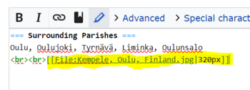
4. Locate the file of the map and remove the wikitext code but leave the <br><br> on the page. An example of the code you should remove:
5. Paste the following wikitext code exactly where you removed the map image:
{{FinlandCOUNTYPARISH}}
6. Change "FinlandCOUNTYPARISH" to match the name of the clickable map template you made in Step 5.
7. Add the following code to the Summary field before saving the page:
/* Surrounding Parishes */ Added Clickable Parish Map
8. Go back to the Task List and put the date next to the parish you finished.
9. Select another parish to work on from the task list and sign your name and repeat the above steps.
