File:TX DUVALL.PNG: Difference between revisions
(Map courtesy of [https://www.digital-topo-maps.com/county-map/Texas.shtml Digital-Topo-Maps.com]. Copyright 2005.<br> Category:Texas Maps Category:Duvall County, Texas) |
m (category) |
||
| Line 2: | Line 2: | ||
Map courtesy of [https://www.digital-topo-maps.com/county-map/Texas.shtml Digital-Topo-Maps.com]. Copyright 2005.<br> | Map courtesy of [https://www.digital-topo-maps.com/county-map/Texas.shtml Digital-Topo-Maps.com]. Copyright 2005.<br> | ||
[[Category:Texas Maps]] | [[Category:Texas Maps]] | ||
[[Category: | [[Category:Duval County, Texas]] | ||
== Licensing == | == Licensing == | ||
{{Digital Topo Maps}} | {{Digital Topo Maps}} | ||
Latest revision as of 09:12, 17 June 2018
Summary[edit | edit source]
Map courtesy of Digital-Topo-Maps.com. Copyright 2005.
Licensing[edit | edit source]
 |
This image is under copyright by the owner, Digital-Topo-Maps and is used by permission under the condition that the copyright is listed and attribution is given. This work is not subject to any Creative Commons license. |
File history
Click on a date/time to view the file as it appeared at that time.
| Date/Time | Thumbnail | Dimensions | User | Comment | |
|---|---|---|---|---|---|
| current | ★ Approved revision 10:22, 14 June 2018 | 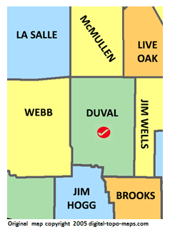 | 238 × 325 (25 KB) | Dotxinxoz (talk | contribs) | Map courtesy of [https://www.digital-topo-maps.com/county-map/Texas.shtml Digital-Topo-Maps.com]. Copyright 2005.<br> Category:Texas Maps Category:Duvall County, Texas |
You cannot overwrite this file.
File usage
The following 2 pages use this file: