Template:GA Toombs County: Difference between revisions
m (Text replacement - "desc none desc none desc none desc none" to "desc none") |
Bethcottam (talk | contribs) (clickable boundary map) |
||
| (4 intermediate revisions by the same user not shown) | |||
| Line 8: | Line 8: | ||
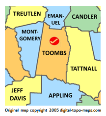
poly 72 147 86 40 75 39 23 54 38 94 45 93 41 106 39 107 46 142 56 144 62 162 71 160 74 146 [[Montgomery County, Georgia Genealogy|Montgomery County]] | poly 72 147 86 40 75 39 23 54 38 94 45 93 41 106 39 107 46 142 56 144 62 162 71 160 74 146 [[Montgomery County, Georgia Genealogy|Montgomery County]] | ||
#<!-- Created by Online Image Map Editor (http://www.maschek.hu/imagemap/index) --> | #<!-- Created by Online Image Map Editor (http://www.maschek.hu/imagemap/index) --> | ||
</imagemap><noinclude>[[Category:Image map templates]]</noinclude> | </imagemap><noinclude>[[Category:Image map templates]]</noinclude> | ||
Revision as of 11:13, 8 January 2019