Template:VA Caroline County: Difference between revisions
Brepouille (talk | contribs) m (Added Category per WA) |
(Template, Clickable Boundry Map) |
||
| (One intermediate revision by one other user not shown) | |||
| Line 8: | Line 8: | ||
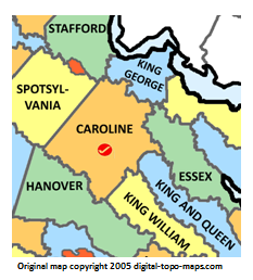
poly 165 66 150 73 152 93 139 100 93 71 99 42 112 53 154 37 160 44 155 61 155 61 [[King George County, Virginia Genealogy|King George County]] | poly 165 66 150 73 152 93 139 100 93 71 99 42 112 53 154 37 160 44 155 61 155 61 [[King George County, Virginia Genealogy|King George County]] | ||
#<!-- Created by Online Image Map Editor (http://www.maschek.hu/imagemap/index) --> | #<!-- Created by Online Image Map Editor (http://www.maschek.hu/imagemap/index) --> | ||
</imagemap> | </imagemap> | ||
<noinclude>[[Category:Image map templates | <noinclude>[[Category:Image map templates]]</noinclude> | ||
Revision as of 09:16, 25 December 2018