Template:MN Rice County: Difference between revisions
m (Text replacement - "--> </imagemap>" to "--> desc none </imagemap>") |
Bethcottam (talk | contribs) (clickable boundary map) |
||
| Line 8: | Line 8: | ||
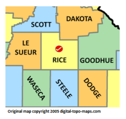
poly 13 146 8 128 20 118 12 111 29 62 94 72 93 156 45 155 54 147 8 148 19 144 [[Le Sueur County, Minnesota Genealogy|Le Sueur County]] | poly 13 146 8 128 20 118 12 111 29 62 94 72 93 156 45 155 54 147 8 148 19 144 [[Le Sueur County, Minnesota Genealogy|Le Sueur County]] | ||
#<!-- Created by Online Image Map Editor (http://www.maschek.hu/imagemap/index) --> | #<!-- Created by Online Image Map Editor (http://www.maschek.hu/imagemap/index) --> | ||
</imagemap><noinclude>[[Category:Image map templates]]</noinclude> | </imagemap><noinclude>[[Category:Image map templates]]</noinclude> | ||
Revision as of 11:22, 7 November 2018