Template:IN Vanderburgh County: Difference between revisions
m (Text replacement - "--> </imagemap>" to "--> desc none </imagemap>") |
Bethcottam (talk | contribs) (clickable boundary map) |
||
| Line 5: | Line 5: | ||
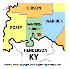
poly 136 208 148 197 156 179 177 178 182 166 168 153 174 136 150 118 128 135 112 123 109 108 102 130 112 142 115 152 89 156 85 133 53 142 37 125 26 135 39 154 67 175 76 204 128 212 [[Henderson County, Kentucky Genealogy|Henderson County]] | poly 136 208 148 197 156 179 177 178 182 166 168 153 174 136 150 118 128 135 112 123 109 108 102 130 112 142 115 152 89 156 85 133 53 142 37 125 26 135 39 154 67 175 76 204 128 212 [[Henderson County, Kentucky Genealogy|Henderson County]] | ||
#<!-- Created by Online Image Map Editor (http://www.maschek.hu/imagemap/index) --> | #<!-- Created by Online Image Map Editor (http://www.maschek.hu/imagemap/index) --> | ||
</imagemap><noinclude>[[Category:Image map templates]]</noinclude> | </imagemap><noinclude>[[Category:Image map templates]]</noinclude> | ||
Revision as of 13:55, 22 September 2018