Template:MOCedar, Missouri Clickable Neighbors: Difference between revisions
No edit summary |
Jabecenti80 (talk | contribs) (Created page with "<imagemap> Image:MOCedar1.JPG poly 242 108 295 105 297 121 337 119 339 182 249 187 Cedar County poly 335 119 419 121 423 217 349 218 343 153 341 142 [[...") |
||
| (3 intermediate revisions by 2 users not shown) | |||
| Line 1: | Line 1: | ||
<imagemap> | <imagemap> | ||
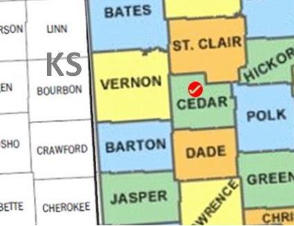
Image:MOCedar1.JPG | Image:MOCedar1.JPG | ||
poly 242 108 295 105 297 121 337 119 339 182 249 187 [[Cedar County, Missouri | poly 242 108 295 105 297 121 337 119 339 182 249 187 [[Cedar County, Missouri|Cedar County]] | ||
poly 335 119 419 121 423 217 349 218 343 153 341 142 [[Polk County, Missouri | poly 335 119 419 121 423 217 349 218 343 153 341 142 [[Polk County, Missouri|Polk County]] | ||
poly 345 219 423 216 423 299 352 302 [[Greene County, Missouri | poly 345 219 423 216 423 299 352 302 [[Greene County, Missouri|Greene County]] | ||
poly 347 254 353 324 261 323 261 262 [[Lawrence County, Missouri | poly 347 254 353 324 261 323 261 262 [[Lawrence County, Missouri|Lawrence County]] | ||
poly 351 300 352 324 423 322 422 300 [[Christian County, Missouri | poly 351 300 352 324 423 322 422 300 [[Christian County, Missouri|Christian County]] | ||
poly 259 259 259 321 148 325 145 248 252 247 252 261 [[Jasper County, Missouri | poly 259 259 259 321 148 325 145 248 252 247 252 261 [[Jasper County, Missouri|Jasper County]] | ||
poly 340 182 342 255 254 260 251 187 [[Dade County, Missouri | poly 340 182 342 255 254 260 251 187 [[Dade County, Missouri|Dade County]] | ||
poly 246 172 250 246 144 248 141 176 [[Barton County, Missouri | poly 246 172 250 246 144 248 141 176 [[Barton County, Missouri|Barton County]] | ||
poly 249 171 244 76 131 76 140 175 [[Vernon County, Missouri | poly 249 171 244 76 131 76 140 175 [[Vernon County, Missouri|Vernon County]] | ||
poly 356 54 423 52 423 0 350 -1 [[Benton County, Missouri | poly 356 54 423 52 423 0 350 -1 [[Benton County, Missouri|Benton County]] | ||
poly 345 122 345 97 358 94 357 56 422 53 420 120 [[Hickory County, Missouri | poly 345 122 345 97 358 94 357 56 422 53 420 120 [[Hickory County, Missouri|Hickory County]] | ||
poly 242 27 352 23 356 93 343 97 344 116 297 120 295 103 240 104 [[St. Clair County, Missouri | poly 242 27 352 23 356 93 343 97 344 116 297 120 295 103 240 104 [[St. Clair County, Missouri|St. Clair County]] | ||
poly 236 0 245 73 132 74 126 -1 [[Bates County, Missouri | poly 236 0 245 73 132 74 126 -1 [[Bates County, Missouri|Bates County]] | ||
poly 236 -1 240 26 344 23 348 0 [[Henry County, Missouri | poly 236 -1 240 26 344 23 348 0 [[Henry County, Missouri|Henry County]] | ||
poly 35 0 38 87 127 82 122 -1 [[Linn County, Kansas | poly 35 0 38 87 127 82 122 -1 [[Linn County, Kansas|Linn County]] | ||
poly 127 81 131 171 42 175 40 86 [[Bourbon County, Kansas | poly 127 81 131 171 42 175 40 86 [[Bourbon County, Kansas|Bourbon County]] | ||
poly 43 176 131 173 136 255 48 261 [[Crawford County, Kansas | poly 43 176 131 173 136 255 48 261 [[Crawford County, Kansas|Crawford County]] | ||
poly 49 259 137 254 140 325 52 325 [[Cherokee County, Kansas | poly 49 259 137 254 140 325 52 325 [[Cherokee County, Kansas|Cherokee County]] | ||
poly 46 249 52 323 1 320 0 252 [[Labette County, Kansas | poly 46 249 52 323 1 320 0 252 [[Labette County, Kansas|Labette County]] | ||
poly 41 162 45 246 -1 250 1 165 [[Neosho County, Kansas | poly 41 162 45 246 -1 250 1 165 [[Neosho County, Kansas|Neosho County]] | ||
poly 38 87 -1 88 0 163 41 164 [[Allen County, Kansas | poly 38 87 -1 88 0 163 41 164 [[Allen County, Kansas|Allen County]] | ||
poly 37 84 37 0 1 0 0 88 [[Anderson County, Kansas | poly 37 84 37 0 1 0 0 88 [[Anderson County, Kansas|Anderson County]] | ||
desc none</imagemap> | desc none | ||
<noinclude>__NORICHEDITOR__ | </imagemap> | ||
[[Category:Image_map_templates]] | |||
<noinclude> | |||
__NORICHEDITOR__ | |||
[[Category:Image_map_templates]] | |||
Revision as of 17:31, 20 March 2014
__NORICHEDITOR__