File:Austria-Hungary map.png
Size of this preview: 776 × 600 pixels. Other resolution: 2,560 × 1,978 pixels.
Original file (2,560 × 1,978 pixels, file size: 516 KB, MIME type: image/png)
Summary[edit | edit source]
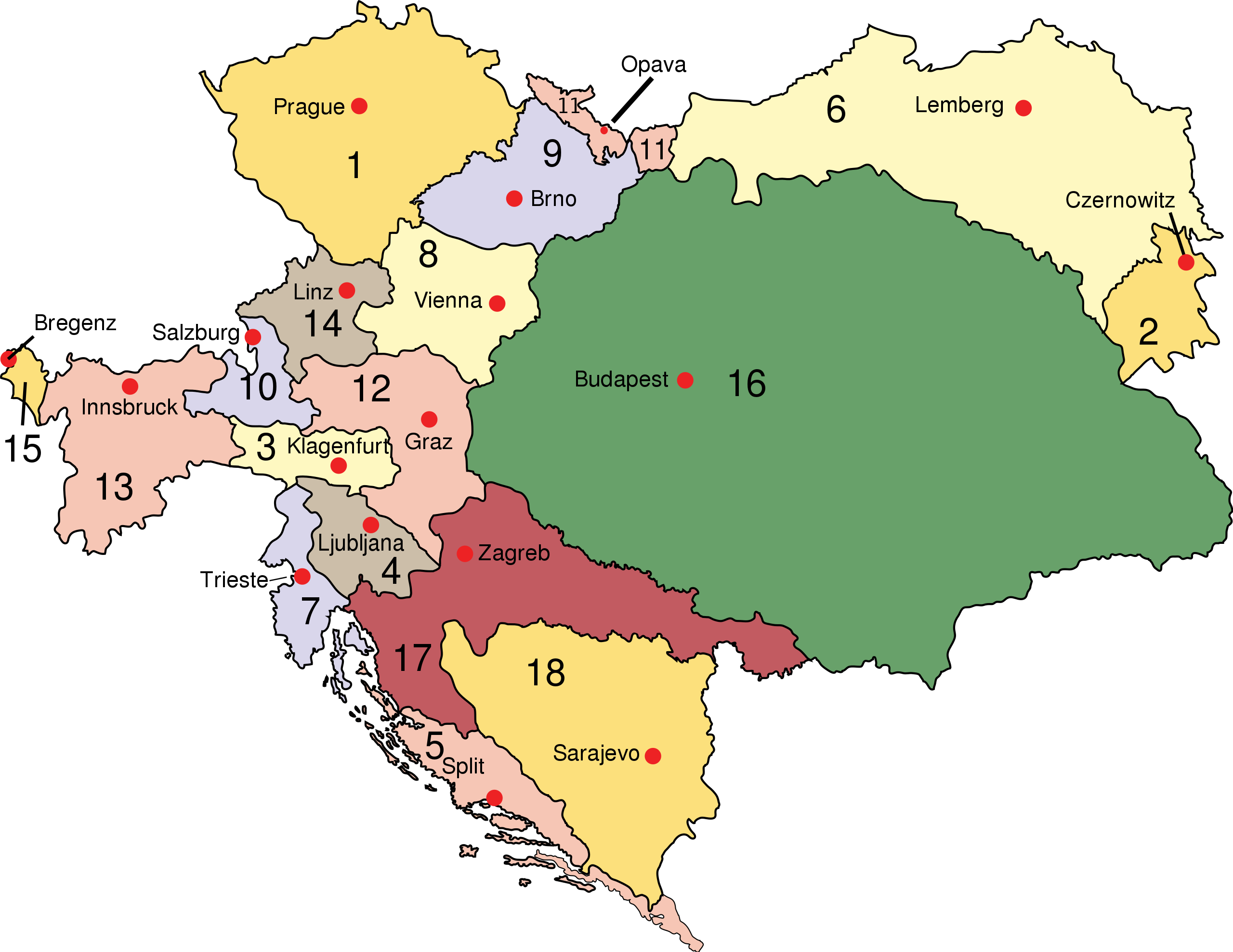
| Description |
Austro-Hungarian Empire: Empire of Austria (Cisleithania): 1. Bohemia, 2. Bukovina, 3. Carinthia, 4. Carniola, 5. Dalmatia, 6. Galicia, 7. Küstenland, 8. Lower Austria, 9. Moravia, 10. Salzburg, 11. Silesia, 12. Styria, 13. Tyrol, 14. Upper Austria, 15. Vorarlberg; Kingdom of Hungary (Transleithania): 16. Hungary 17. Croatia-Slavonia; Austrian Condominium: 18. Bosnia and Herzegovina |
|---|---|
| Author |
IMeowbot |
| Source |
https://commons.wikimedia.org/wiki/File:Austria-Hungary_map.svg |
| Date |
14 August 2006 |
| Permission |
Public Domain |
Licensing[edit | edit source]
|
|
This work has been released into the public domain by the copyright holder. This applies worldwide. In case this is not legally possible: The copyright holder grants any entity the right to use this work for any purpose, without any conditions, unless such conditions are required by law. |
File history
Click on a date/time to view the file as it appeared at that time.
| Date/Time | Thumbnail | Dimensions | User | Comment | |
|---|---|---|---|---|---|
| current | ★ Approved revision 15:52, 29 June 2022 | | 2,560 × 1,978 (516 KB) | Gublerjones (talk | contribs) | {{Information | Description = Austro-Hungarian Empire | Source = https://commons.wikimedia.org/wiki/File:Austria-Hungary_map.svg | Date = 14 August 2006 | Author = IMeowbot | Permission = Public Domain }} Category:ADD CATEGORY HERE |
You cannot overwrite this file.
File usage
The following 4 pages use this file: