Berkshire County, Massachusetts Genealogy
Guide to Berkshire County, Massachusetts ancestry, genealogy and family history, birth records, marriage records, death records, census records, and military records.
|
| ||||||||||||||||||||
| ||||||||||||||||||||


County Information[edit | edit source]
Description[edit | edit source]
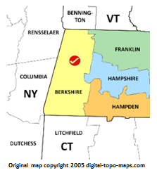
Berkshire County has always been at the crossroads of settlers on the move. As the western side of the Berkshire Mountains, those moving west from all other Massachusetts counties, Rhode Island, and much of Connecticut, and occasionally from very southern New Hampshire and Vermont would converge here. Many would continue west into New York state or up the western side of Vermont following the first roads that allowed easy travel through this region. It was never a populous county, but the rugged terrain was often where "lost" ancestors called home. Berkshire's county government was abolished on 1 July 2000, but its former jurisdiction is used for state offices as a district.[3]
The county was named for Berkshire, England.[4] It is located in the western area of the state.[5]
County Courthouse[edit | edit source]
Berkshire Regional Planning Commission
76 East St.
Pittsfield, MA 01201
Phone: 413-499-7487
Berkshire Courthouse
Berkshire County, Massachusetts Record Dates[edit | edit source]
Information for this chart was taken from various sources, often containing conflicting dates. This information should be taken as a guide and should be verified by contacting the county and/or the state government agency.
| Birth* | Marriage | Death* | Court | Land | Probate | Census |
| at town creation | at town creation | at town creation | 1761 | 1761 | 1761 | 1779 |
Record Loss[edit | edit source]
|
There is no known history of courthouse disasters in this county. |
Boundary Changes[edit | edit source]
|
Populated Places[edit | edit source]

For a complete list of populated places, including small neighborhoods and suburbs, visit HomeTown Locator. The following are the most historically and genealogically relevant populated places in this county:[9]
| Cities | ||
| Towns | ||
| Villages | ||
| Census-designated places | ||
History Timeline[edit | edit source]
The basic data are from the historical county boundary series[10] with additions from various sources.
cellpadding="1" border="1" width="100%"
|-
! width="15%" scope="col" | Dates
! width="85%" scope="col" | Events
|-
| 30 June 1761
| Berkshire County was created from the western third of Hampshire County. [Mass. Col. Acts, Vol. 4, Ch. 33 [1760/1], Sec. 1, p. 432]
|-
| 30 June 1768
| Loss when part of Plantation #3 was included in the new town of Worthington, Hampshire Co. [Mass. Col. Acts, Vol. 4, Ch. 16 [1768], Sec. 1, p. 1028]
|-
| 23 June 1779
| Loss when part of Plantation #5 was included in the new town of Cummington, Hampshire Co. [Mass. Col. Acts, Vol. 5, Ch. 6 [1779/80], Sec. 1, p. 1072-1073]
|-
| 12 Mar. 1783
| Loss when parts of Becket, Partridgefield [now Peru], and Washington along with Chester, Prescott's Grant, and Worthington in Hampshire Co. were included in the new town of Middlefield, Hampshire Co. [Mass. Acts, 1783, Ch. 19, Sec. 1, p. 228]
|-
| 9 Feb. 1785
| Loss when Myrifield Grant and unincorporated county land created the new town of Rowe, Hampshire Co. [Mass. Acts, 1785, Ch. 2, Sec. 1, p. 230]
|-
| 9 Mar. 1793
| Loss when part of Plantation #7 was annexed to Hawley, Hampshire Co. [Mass. Acts, 1793, Ch. 18, Sec. 1, p. 242]
|-
| 21 Feb. 1822
| Loss when the Gore was combined with the western part of Rowe, Hampshire Co., to create the new town of Monroe, Hampshire. [Mass. Acts, 1822, Ch. 93, Sec. 1, p. 707]
|-
| 2 Apr. 1838
| Loss when part of the territory known as Zoar was annexed to Charlemont and Rowe, Hampshire Co. [Mass. Acts 1838, Ch. 56, Sec. 1, p. 344 and Ch. 57, Sec. 1, p. 345]
|-
| 4 May 1853
15 May 1855
| Border between Sandisfield and Tolland, Hampden Co., clarified then redefined. [Mass. Acts, 1853, Ch. 293, p. 535; 1855, Ch. 358, Sec. 1, p. 755]
|-
| 11 Jan. 1855
| Loss when the southwest corner of the county [and state] known as Boston Corner annexed to Columbia Co., N.Y.
|}
Resources[edit | edit source]
Bible Records[edit | edit source]
Biographies[edit | edit source]
Business, Commerce, and Occupations[edit | edit source]
- 1837-1965 Maine & Massachusetts Case Files of Deceased and Deserted Seamen 1837-1965 at FamilySearch — How to Use this Collection; Images only
Cemeteries[edit | edit source]
Census Records[edit | edit source]
| Historical populations | ||
|---|---|---|
| Census | Pop. | %± |
| 1790 | 30,263 | — |
| 1800 | 33,885 | 12.0% |
| 1810 | 35,907 | 6.0% |
| 1820 | 35,720 | −0.5% |
| 1830 | 37,835 | 5.9% |
| 1840 | 41,745 | 10.3% |
| 1850 | 49,591 | 18.8% |
| 1860 | 55,120 | 11.1% |
| 1870 | 64,827 | 17.6% |
| 1880 | 69,032 | 6.5% |
| 1890 | 81,108 | 17.5% |
| 1900 | 95,667 | 18.0% |
| 1910 | 105,259 | 10.0% |
| 1920 | 113,033 | 7.4% |
| 1930 | 120,700 | 6.8% |
| 1940 | 122,273 | 1.3% |
| 1950 | 132,966 | 8.7% |
| 1960 | 142,135 | 6.9% |
| 1970 | 149,402 | 5.1% |
| 1980 | 145,110 | −2.9% |
| 1990 | 139,352 | −4.0% |
| 2000 | 134,953 | −3.2% |
| 2010 | 131,219 | −2.8% |
| Source: "Wikipedia.org". | ||
- 1865 Massachusetts State Census, 1865 at FamilySearch — How to Use this Collection; Index and images
Church Records[edit | edit source]
List of Churches and Church Parishes
Court Records[edit | edit source]
The court system can appear to be complex. The system was reorganized in 1686/1692, 1859, and 1978. Described below are the most commonly used records for history and genealogy, but realize that this list is incomplete. For more detailed information regarding court structure, see Understanding the Massachusetts Court System.
- Supreme Judicial Court Archives (older records)
(administration - records stored in several off-site facilities and the Mass. Archives)
16th Floor, Highrise Court House
3 Pemberton Square
Boston MA 02109
Phone 617-557-1082
Email Elizabeth.Bouvier@sjc.state.ma.us
Quarterly Court of General Sessions of the Peace
This court was active from 1761 to 1827. The court heard criminal cases and had authority over county affairs that included levying taxes, reviewing town bylaws, highways, licensed liquor, regulated jails, supervised the administration of the poor laws, and appointed some county officials.
There are no records microfilmed. Contact the Supreme Judicial Court Archivist above for the location of the original records.
Inferior Court of Common Pleas
This court was active from 1761 to 1859. The court heard all civil cases over 40s unless a case involved freehold or was appealed from a justice of the peace.
Online Court Index and Records:
- 1760-1860 Records, 1760-1860; Indexes, 1761-1854(*) Berkshire County Court of Common Pleas at FamilySearch Catalog - images.
Superior Court
The Quarterly Court of General Sessions was merged into the Inferior Court of Common Pleas in 1827, and that court was reorganized in 1859 to created the Superior Court as the new lower (i.e. trial) court. It covers both criminal and civil matters.
Online Court Index and Records:
- 1847-1916 Divorce Records, 1887-1916(*) Berkshire County Superior Court at FamilySearch Catalog - images
- 1847-1940 Divorce Record Indexes, 1847-1940(*) Berkshire County Superior Court at FamilySearch Catalog - images
- 1888-1927 Divorce Docket Books 1888-1927(*) Berkshire County Superior Court at FamilySearch Catalog - images
- 1888-1927 Divorce docket books, v. 1-8, 1888-1927 at Massachusetts Archives
Supreme Judicial Court
The Supreme Judicial Court was established by the Massachusetts Constitution of 1780 that combined the former Governor and Council with the Superior Court of Judicature creating the highest state court. This court hears appeals, writ of error, capital offenses, and crimes against the public good. That included divorces until that action was moved to the lower court in 1887.
Online Court Index and Records:
- 1877-1887 Divorce Records, 1877-1887(*) Berkshire County Supreme Court at FamilySearch Catalog - images
Insolvency Court
Online Court Index and Records:
- 1860-1899 Court Dockets, 1860-1899(*) Berkshire County Insolvency Court at FamilySearch Catalog - images
- 1879-1899 Certificates of Discharge, 1879-1899(*) Berkshire County Insolvency Court at FamilySearch Catalog - images
Directories[edit | edit source]
- 1725-1885 Gazetteer of Berkshire County, Massachusetts, 1725-1885 (1885) at MyHeritage — index & images ($)
- 1970-2024 United States, Residence Database, 1970-2024 at FamilySearch — How to Use this Collection; index, coverage may vary
Emigration and Immigration[edit | edit source]
Ethnic, Political, and Religious Groups[edit | edit source]
Funeral Homes[edit | edit source]
|
Genealogies[edit | edit source]
Guardianship[edit | edit source]
Land and Property Records[edit | edit source]
Land transfers, commonly called deeds, are recorded on the county level in Massachusetts. Not all deeds were recorded as is common practice today. The earliest transactions were charters or grants from the English Crown. Once local government was established, the colony would grant land to settlers directly or to towns to dole out. Some towns first start out as proprietorship and records were recorded there. Once towns were established, deeds were recorded on the county level.
Berkshire County is divided into three land districts:
Northern Berkshire District Registry of Deeds
65 Park Street
Adams MA 01220
Phone 413-743-0035
Email nbrd@sec.state.ma.us
This district covers Adams, Cheshire, Clarksburg, Florida, Hancock, Lanesborough, New Ashford, North Adams, Savoy, Williamstown, and Windsor.
Online Land Indexes and Records
- Pre-1960 Recorded Land (i.e. deeds), Pre-1960 at Northern Berkshire Registry of Deeds; indexed by grantor and grantee, book, and page number
- Pre-1960 Grantee Index and Grantor Index, Pre-1960 at Northern Berkshire Registry of Deeds
- 1761-1985 Land Records - Northern District, 1761-1925, and Index, 1761-1985 Berkshire County Register of Deeds at FamilySearch Catalog - images
- 1770-Current Recorded Plans, 1770-present at Northern Berkshire Registry of Deeds
- 1899-Current Registered Land Plans, 1899-present at Northern Berkshire Registry of Deeds
- 1944-Current Registered Land [i.e. land court, 1944-present] at Northern Berkshire Registry of Deeds
- 1960-Current Recorded Land (i.e. deeds), 1960-present at Northern Berkshire Registry of Deeds; indexed by grantor and grantee, book, and page number
- Colonial Records and Proprietary Plans: a Compilation of the Proprietors Lots, Grants, Plantations and Colonial Records of the Middle, Northern, and Southern Districts of Berkshire County(*) Northern Berkshire Register of Deeds at FamilySearch Catalog - images
Berkshire Middle District Registry of Deeds
44 Bank Row
Pittsfield MA 01201
Phone 413-443-7438
This district covers Becket, Dalton, Hinsdale, Lee, Lenox, Otis, Peru, Pittsfield, Richmond, Stockbridge, Tyringham, and Washington.
Online Land Indexes and Records
- Pre-1969 Grantee Index and Grantor Index, Pre-1969 at Berkshire Middle Registry of Deeds; Instructions
- Pre-1970 Recorded Land (i.e. deeds), 1970-Present at Berkshire Middle Registry of Deeds; indexed by grantor and grantee, book, and page number; Instructions
- 1761-1925 Land Records - Middle District, 1761-1925, and Indexes, 1761-1907 Berkshire Register of Deeds at FamilySearch Catalog images; Early Middle District grantee and grantor indexes are those titled as covering the years 1761-1830.
- 1761-1925 Land Records - Middle District, 1761-1925, and Indexes, 1761-1907 at New England Historic Genealogical Society
- 1761-1969 Unindexed Property Search, 1761-1969 at Berkshire Middle Registry of Deeds, Instructions
- 1800-Current County Commissioner Plans, 1800-Present at Berkshire Middle Registry of Deeds; Instructions
- 1899-Current Registered Land Plans, 1899-Present[ at Berkshire Middle Registry of Deeds; Instructions
- 1970-Current Recorded Land (i.e. deeds), 1970-Present at Berkshire Middle Registry of Deeds; indexed by name, book and page number; Instructions
- Colonial Records and Proprietary Plans: a Compilation of the Proprietors Lots, Grants, Plantations and Colonial Records of the Middle, Northern, and Southern Districts of Berkshire County(*) Middle Berkshire Register of Deeds at FamilySearch Catalog - images
Southern Berkshire District Registry of Deeds
334 Main Street - Suite 2
Great Barrington MA 01230
Phone 413-528-0146
Email SBRD@sec.state.ma.us
This district covers Alford, Egremont, Great Barrington, Monterey, Mount Washington, New Marlborough, Sandisfield, Sheffield, and West Stockbridge.
Online Land Indexes and Records
- Pre-1960 Recorded Land (i.e. deeds), Pre-1960 at Southern Berkshire Registry of Deeds; indexed by grantor and grantee, book, and page number
- Pre-1960 Grantee Index and Grantor Index, Pre-1960 at Southern Berkshire Registry of Deeds
- 1731-1959 Unindexed Property Search, 1731-1959 at Southern Berkshire Registry of Deeds, by book and page
- 1790-1923 Land Records - Southern District, 1790-1900, Indexes, 1790-1923 Berkshire County Register of Deeds at FamilySearch Catalog - images
- 1847-Current Recorded Plans, 1847-present at Southern Berkshire Registry of Deeds
- 1908-Current Registered Land (i.e. land court), 1908-present at Southern Berkshire Registry of Deeds
- 1908-Current Registered Land Plans, 1908-present at Southern Berkshire Registry of Deeds
- 1960-Current Recorded Land (i.e. deeds), 1960-present at Southern Berkshire Registry of Deeds; indexed by grantor and grantee, book, and page number
- Colonial Records and Proprietary Plans: a Compilation of the Proprietors Lots, Grants, Plantations and Colonial Records of the Middle, Northern, and Southern Districts of Berkshire County(*) Southern Berkshire Register of Deeds at FamilySearch Catalog - images
- Full-Text Search - Land Records at FamilySearch - index & images; dates, records, and places vary; How to Search
Local Histories[edit | edit source]
Works written on the county include:
- Massachusetts: Historical Data Relating to Cities and Towns at American Ancestors — index & images ($)
- Biographical Review containing life sketches of leading citizens of Berkshire County, Massachusetts (Boston, 1899), 596 pp.
WorldCat (Other Libraries); FS Catalog book 974.41 D3b and film 1320579 Item 2.
No digital version found. - Hamilton Child, comp., Gazetteer of Berkshire County, Mass., 1725-1885 (Syracuse, N.Y., 1885), 2v. in 1.
WorldCat (Other Libraries); Index; FS Library film 1425650 Item 1 (with digital link).
Digital versions at Internet Archive and Google Books. - "Early Superior Court History: Origin in Berkshire County" in Berkshire Hills, New Ser., 2 [1905/6]: 134.
WorldCat (Other Libraries); Not at FS Library.
No digital version found. - David Dudley Field and Chester Dewey, eds., A History of the County of Berkshire, Massachusetts (Pittsfield, Mass., 1829), iv, 468 pp.
WorldCat (Other Libraries); FS Library film 234601 and FS Catalog book 974.41 H2h index.
Digital versions at Internet Archive and Google Books. - Joseph Hooper, "The Protestant Episcopal Church in Berkshire" in Berkshire Historical and Scientific Society. Collections, 1: 3 [1890]: 185-212.
WorldCat (Other Libraries); Not at FS Library.
No digital version found. - Pink Horwitt and Bertha Skole, Jews in Berkshire County (Williamstown, Mass., 1972), viii, 74 pp.
WorldCat (Other Libraries); Not at FS Library. - Cathy Kelly, "Marriage Migration as a Measure of interaction in Massachusetts," Ph.D. Dissertation, Syracuse Univ., 1982, ix, 328 pp.
Note: Berkshire County study, mid-18th to mid-19th centuries.
WorldCat (Other Libraries); Not at FS Library. - Alice P. Kenney, "Lost Colonists: The Dutch in Berkshire County" in The New-England Galaxy, 19 [Summer 1977), 3-16.
WorldCat (Other Libraries); FS Library does not have this issue. - S. P. Parker, "History of Episcopal Church in Berkshire County" in Collections of the Berkshire Historical and Scientific Society, 2: 2 [1895]: 83-92.
WorldCat (Other Libraries); Not at FS Library.
Digital versions at Internet Archive, Google Books, and Hathi Trust. - "Pioneer Colored Folks of Berkshire, mostly fugitives from slavery" in Berkshire Hills, 3 [1902/3]: 101-104.
WorldCat (Other Libraries); Not at FS Library.
No digital version found. - Henry W. Taft, "Judicial History of Berkshire" in Collections of the Berkshire Historical and Scientific Society, 1: 1 [1886]: 89-115.
WorldCat (Other Libraries); Not at FS Library.
Digital versions at Internet Archive and Hathi Trust. - The Berkshire County MAGenWeb Project, an member of The MAGenWeb Project, an affiliate of The USGenWeb Project.
- The USGenWeb Archives Project for Berkshire County.
Maps and Gazetteers[edit | edit source]
for more resources
- A Map of Berkshire County Mass. (ca. 1830) at the Norman B. Leventhal Map Center, Boston Public Library.
- F. W. Beers, County Atlas of Berkshire, Massachusetts (New York, 1876), FS Library CD-ROM no. 1485.
- Henry F. Walling, Map of the County of Berkshire, Massachusetts (1858), at the Norman B. Leventhal Map Center, Boston Public Library, and FS Library fiche 6079544.
- FamilySearch Places: Map of cities and towns in this county - How to Use FS Places
There are so many published maps of interest to genealogists and historians that this list will not be recreated here. The focus is with resources you can access online and in the FamilySearch Library.
Migration[edit | edit source]

Migration routes for early European settlers to and from Berkshire County included:[11]
- Hudson River a navigable river stretching from north of Albany then flowing south to empty into the Atlantic Ocean at New York City
- Albany Post Road from New York City to Albany, New York[12] 1669
- Alford and Egremont (MA) Turnpike[13] 1812
- Ancram (NY) Turnpike[14] 1805, also sometimes called the Catskill Road, from Salisbury, Connecticut to Catskill, New York
- Catskill Road 1750s from Springfield, Massachusetts to Catskill, New York[15] [16] [17] [18] [19]
- Catskill Turnpike (aka Susquehannah Turnpike ) from Catskill, NY to Unadilla, NY; route travelled by Europeans by 1792; toll booths opened by 1804.[20] [21] [22]
- Columbia (NY) Turnpike 1799
- Great Barrington and Aford (MA) Turnpike[23] 1812
- Greenwood Road[24] 1799 from Hartford, Connecticut to Albany, New York
- Hampden and Berkshire (MA) Turnpike[25] 1826
- Hillsdale and Chatham Turnpike 1805 from Alford, Massachusetts to Albany, New York
- Housatonic River (MA) Turnpike[26] 1809
- Massachusetts 10th Turnpike[27] 1800
- Massachusetts 12th Turnpike[28] 1812
- Minsi Path 1766 from Philadelphia, Pennsylvania to Kingston, New York[29] [30]
- Mohawk or Iroquois Trail[31] [32] [33] 1722 from Boston, Massachusetts to Fort Oswego, New York
- Old Connecticut Path[34] [35] [36] 1630 from Boston, Massachusetts to Hartford, Connecticut
- Rensselaer and Columbia (NY) Turnpike 1799
- Salisbury and Canaan (CT) Turnpike[37] 1801-1829
- Ulster and Delaware Turnpike 1802 from Salisbury, Connecticut to Bainbridge, New York
Military Records[edit | edit source]
Revolutionary War
- 1775-1783 Massachusetts, Revolutionary War, Index Cards to Muster Rolls, 1775-1783 at FamilySearch — How to Use this Collection; Index and images
- 1805-1845 Massachusetts Revolutionary War Bounty Land Applications, 1805-1845 at FamilySearch — How to Use this Collection; Index and images
- 1818-1825 Revolutionary War Pension Papers, 1818-1825, Berkshire County, Massachusetts at FamilySearch Catalog - images
Civil War
- 1861-1865 U.S., Civil War Soldier Records and Profiles, 1861-1865 also known as Civil War Research Database, at Ancestry — Index ($)
World War I
Naturalization and Citizenship[edit | edit source]
Naturalization records were created on a variety of governmental levels from the Federal down to the city at the same time. The county records for all levels are outlines below. For more information, see the Massachusetts state page for more on naturalization.
Online Naturalization Indexes and Records - Covering Multiple Courts
- 1871-1991 Massachusetts, United States Naturalization Records, 1871-1991 at FamilySearch — How to Use this Collection; Index and images
- 1906-1817 Massachusetts, Naturalization Records, 1906-1917 at FamilySearch — How to Use this Collection; Index and images
Online Federal Naturalization Indexes and Records for Various Federal Courts in Berkshire County
Various Federal Courts - Originals at NARA M1299, National Archives - Waltham
Indexes
- 1791-1906 United States, New England Petitions for Naturalization Index, 1791-1906(*) at FamilySearch - How to Use this Collection; images
- 1791-1906 Index to New England Naturalization Petitions, 1791-1906 at FamilySearch Catalog - images
Records
- 1787-1860 Pittsfield, Court of Common Pleas Naturalization Records, 1787-1860 at FamilySearch Catalog - images
- 1787-1876 Pittsfield, Supreme Judicial Court Naturalization Records, 1787-1876 at FamilySearch Catalog - images
- 1885-1906 Pittsfield, District Court Naturalization Records, 1885-1906 at FamilySearch Catalog - images
- 1886-1906 Great Barrington, District Court of Southern Berkshire, Naturalization Records, 1886-1906 at FamilySearch Catalog - images
- 1891-1906 North Adams, District Court Naturalization Records, 1891-1906 at FamilySearch Catalog - images
- 1895-1906 Adams, District Court Naturalization Records, 1895-1906 at FamilySearch Catalog - images
- 1900-1906 Lee, Police Court Naturalization Records, 1900-1906 at FamilySearch Catalog - images
Online County Courts Naturalization Indexes and Records
Indexes
- 1815-1906 Naturalization Index, 1815-1906 - Court of Common Pleas, Superior Court and Supreme Judicial Court at FamilySearch Catalog - images
- 1815-1985 Naturalization Record Index Cards, 1815-1985 - Superior Court at FamilySearch Catalog - images
Records
- 1826-1945 Naturalization Petitions and Records, 1891-1934, 1937-1945, Index 1826-1938 - Superior Court at FamilySearch Catalog - images
- 1829-1945 Naturalization Declarations of Intention, 1906-1945; Index 1829-1936 - Superior Court at FamilySearch Catalog - images; index in each volume
- 1843-1856 Naturalization Records, 1843-1856 - Court of Common Pleas and Supreme Judicial Court at FamilySearch Catalog - images
- 1848-1885 Naturalization Declarations and Petitions, 1848-1885 - Court of Common Pleas, Superior Court and Supreme Judicial Court at FamilySearch Catalog - images; index in each volume
- 1856-1887 Previous Declarations and Petitions for Naturalizaton (Docket Book), 1856-1887 - - Court of Common Pleas, Superior Court and Supreme Judicial Court at FamilySearch Catalog - images
- 1866-1941 Naturalization Records, ca. 1866-1941 - Superior Court at FamilySearch Catalog - images
- 1885-1906 Naturalization Records Index, Petitions and Oaths, and Declarations and Intentions; 1885-1906 - District Court at FamilySearch Catalog - images
Newspapers[edit | edit source]
- 1800-Current Massachusetts, U.S., Newspapers.com™ Stories and Events Index, 1800's Current at Ancestry — index & images ($)
Obituaries[edit | edit source]
Other Records[edit | edit source]
Periodicals[edit | edit source]
Probate Records[edit | edit source]
Probate and Family Court is organized on a county level in Massachusetts since the creation of the counties. The main records genealogists seek are testate (wills), intestate (administrations), guardianships, and divorces (since 1922), though there are many more that are valuable to any researcher, too. See a further discussion of the topic in general on the Massachusetts Genealogy Guide.
Berkshire Probate and Family Court
44 Bank Row
Pittsfield MA 01201
Phone 413-442-6941
Original Records
The original indexes, dockets, records, and files from 1761 to 1865 are at the Judicial Archives in Boston. Records after 1865 are at the courthouse. The file papers exist, but have never been microfilmed or digitized. The first docket book [i.e. the key to the recorded records] was never microfilmed and represents a major obstacle for probates before 1835.
Online Probate Indexes and Records
- 1635-1991 Massachusetts Wills and Probate Records 1635-1991 at Ancestry — index & images ($)
- 1761-1900 Berkshire County Probate Index, 1761-1900 at The Massachusetts Society of Mayflower Descendants - index
- 1761-1917 Probate Records, 1761-1917(*) Berkshire County Probate Court at FamilySearch Catalog - index & images
- 1761-1917 Berkshire County, MA: Probate File Papers, 1761-1917 at American Ancestors - index & images ($)
- 1860-1899 Court Dockets, 1860-1899(*) Berkshire County Court of Insolvency at FamilySearch Catalog - index & images
- 1878-1910 Records of Assignments, 1878-1910(*) Berkshire County Court of Insolvency at FamilySearch Catalog - index & images
- 1879-1899 Certificates of Discharge, 1879-1899(*) Berkshire County Court of Insolvency at FamilySearch Catalog - index & images
- 1884-1917 Probate Records, 1884-1917(*) Berkshire County Probate Court at FamilySearch Catalog - index & images
- 1894-1907 Record of Adjournments, 1894-1907(*) Berkshire County Probate Court and Court of Insolvency at FamilySearch Catalog - index & images
- 1907-1921 Inheritance Tax Records, 1907-1921(*) Berkshire County Probate Court at FamilySearch Catalog - index & images
- Full-Text Search - Wills and Probate Records at FamilySearch - index & images; dates, records, and places vary; How to Search
Original Records on Microfilm at New England Historic Genealogical Society:
- Probate Index, 1761-1930 [i.e. index to docket books]
- Probate Dockets, #5575-30403, 1835-1917 [Note: First docket book never filmed]
- Probate Records, v. 1-224, 1761-1916 [Note: v. 1-58, 1761-1865, also at Massachusetts Archive]
- Inheritance Tax Records, v. 1-2, 1907-1921
- Record of adjournments, 1894-1907
- Court of Insolvency, dockets, v. 3-4, 1860-1899
- Court of Insolvency, records of assignments, v. 2, 1878-1910
- Court of Insolvency, certificates of discharge, 1879-1899
School Records[edit | edit source]
Social Security Records[edit | edit source]
- 1935-2014 United States Social Security Death Index at FamilySearch — How to Use this Collection; index. Also at Ancestry, findmypast, Fold3, GenealogyBank, MyHeritage, and Steve Morse. Click here for more information.
- 1936-2007 U.S., Social Security Applications and Claims Index, 1936-2007
- 1936-2007 United States, Social Security Numerical Identification Files (NUMIDENT), 1936-2007 at FamilySearch - How to Use this Collection; index
Tax Records[edit | edit source]
Town Records[edit | edit source]
- 1626-2001 Massachusetts, Town Clerk, Vital and Town Records, 1626-2001 at FamilySearch — How to Use this Collection; Index and images
Vital Records[edit | edit source]
It is easiest to start with the state vital records indexes (listed below) for births, marriages, and deaths since 1841. Massachusetts was the first to require a consistent recording of these events statewide. Original vital records (starting as early as 1639) are found with the clerk of the town or city where the event occurred. See the Massachusetts Genealogy Guide and Massachusetts Vital Records pages for more details.
Birth[edit | edit source]
- 1626-2001 Massachusetts, Town Clerk, Vital and Town Records, 1626-2001 at FamilySearch — How to Use this Collection; Index and images
- 1638-1961 Massachusetts Town Records, ca. 1638-1961 at FamilySearch — How to Use this Collection; Index and images
- 1753-1900 Massachusetts, Delayed and Corrected Vital Records, 1753-1900 at FamilySearch — How to Use this Collection; Index and images
- 1840-1910 Massachusetts, Birth Index, 1840-1910 at MyHeritage - index ($)
- 1841-1920 Massachusetts State Vital Records, 1841-1920 at FamilySearch — How to Use this Collection; Index and images
Marriage[edit | edit source]
- 1600-1961 Massachusetts, United States Marriages at at Findmypast — index ($) — index $
- 1626-2001 Massachusetts, Town Clerk, Vital and Town Records, 1626-2001 at FamilySearch — How to Use this Collection; Index and images
- 1638-1961 Massachusetts Town Records, ca. 1638-1961 at FamilySearch — How to Use this Collection; Index and images
- 1841-1915 Massachusetts Marriages, 1841-1915 at FamilySearch — How to Use this Collection; Index and images
- 1841-1915 Massachusetts, Marriages, 1841-1915 at MyHeritage - index ($)
- 1841-1920 Massachusetts State Vital Records, 1841-1920 at FamilySearch — How to Use this Collection; Index and images
Death[edit | edit source]
- 1626-2001 Massachusetts, Town Clerk, Vital and Town Records, 1626-2001 at FamilySearch — How to Use this Collection; Index and images
- 1840-1910 Massachusetts Death Index at MyHeritage - index only ($)
- 1841-1920 Massachusetts State Vital Records, 1841-1920 at FamilySearch — How to Use this Collection; Index and images
- 1916-1919 Massachusetts Deaths, 1916-1919 at MyHeritage — index & images ($)
Divorce[edit | edit source]
- 1847-1916 Divorce Records, 1887-1916(*) Berkshire County Superior Court at FamilySearch Catalog - images
- 1847-1940 Divorce Record Indexes, 1847-1940(*) Berkshire County Superior Court at FamilySearch Catalog - images
- 1877-1887 Divorce Records, 1877-1887(*) Berkshire County Supreme Court at FamilySearch Catalog - images
- 1888-1927 Divorce Docket Books 1888-1927(*) Berkshire County Superior Court at FamilySearch Catalog - images
- 1888-1927 Divorce docket books, v. 1-8, 1888-1927 at Massachusetts Archives
Research Facilities[edit | edit source]
Archives[edit | edit source]
For state-wide and regional facilities, see Massachusetts Archives and Libraries.
FamilySearch Centers[edit | edit source]
FamilySearch Center and Affiliate Library Locator map - search for local FamilySearch Centers or Affiliate Libraries
- FamilySearch Centers provide one-on-one assistance, free access to center-only databases, and to premium genealogical websites.
- FamilySearch Affiliate Libraries have access to most center-only databases, but may not always have full services normally provided by a FamilySearch center.
Local Centers and Affiliate Libraries
- Albany New York FamilySearch Center
- Bennington Vermont FamilySearch Center
- Berkshire Athenaeum, Pittsfield Public Library - an affiliate library
- Berkshire Family History Association, Inc. - an affiliate library
- Worcester Public Library - an affiliate library
Libraries[edit | edit source]
Listed below are libraries in Berkshire County. For state-wide library facilities, see Massachusetts Archives and Libraries.
Berkshire Athenaeum
One Wendell Avenue
Pittsfield MA 01201
Phone 413-499-9480
Email pittsref@cwmars.org
Premier genealogical collection and recipient of the NARA Pittsfield microfilm.
Website
Berkshire Family History Association
PO Box 1437
Pittsfield MA 01202
Website
For information on additional archives and repositories, see:
Massachusetts Archives for information on additional archives and repositories
Museums[edit | edit source]
Societies[edit | edit source]
Listed below are societies in Berkshire County. For state-wide genealogical and historical societies, see Massachusetts Societies.
Berkshire Historical Society
780 Holmes Road
Pittsfield MA 01201
413-442-1793
Email: melville@berkshirehistory.org
Website
Berkshire County Historical Societies CountyOffice.orgWebsite
Websites[edit | edit source]
- FamilySearch Catalog – The FamilySearch catalog contains descriptions and access information for all genealogical materials (including books, online materials, microfilm, microfiche, and publications) in their collection. Use Historical Records to search for specific individuals in genealogical records.
Research Guides[edit | edit source]
References[edit | edit source]
- ↑ Individual County Chronologies by John H Long; online by Newberry Library
- ↑ Individual County Chronologies by John H Long; online by Newberry Library
- ↑ Abolished County Governments - Secretary of State, Acts of 1998, Ch. 300, Sect. 11.
- ↑ Britannica, “Berkshire County, Massachusetts, https://www.britannica.com/place/Berkshire-county-Massachusetts
- ↑ Wikipedia contributors, "Berkshire, County," in Wikipedia: the Free Encyclopedia, https://en.wikipedia.org/wiki/Berkshire_County,_Massachusetts
- ↑ Handybook for Genealogists: United States of America, 10th ed. (Draper, Utah: Everton Pub., 2002), Berkshire County, Massachusetts . Page 329-331 At various libraries (WorldCat); FS Library Book 973 D27e 2002; Alice Eichholz, ed. Ancestry’s Red Book: American State, County, and Town Sources, Third ed. (Provo, Utah: Ancestry, 2004), 322-323.
- ↑ Individual County Chronologies by John H Long; online by Newberry Library
- ↑ Handybook for Genealogists: United States of America, 10th ed. (Draper, Utah: Everton Pub., 2002), Massachusetts. At various libraries (WorldCat); FS Library Book 973 D27e 2002.
- ↑ Wikipedia contributors, "Berkshire County, Massachusetts," in Wikipedia: the Free Encyclopedia, https://en.wikipedia.org/wiki/Berkshire_County%2C_Massachusetts, accessed 08 March 2020.
- ↑ Massachusetts Atlas of Historical County Boundaries
- ↑ Handybook for Genealogists: United States of America, 10th ed. (Draper, Utah: Everton Pub., 2002), 847-61. WorldCat entry; FS Library Book 973 D27e 2002.
- ↑ Wikipedia contributors, "Old Albany Post Road" in Wikipedia: the Free Encyclopedia at http://en.wikipedia.org/wiki/Old_Albany_Post_Road (accessed 23 June 2011).
- ↑ Frederic J. Wood, The Turnpikes of New England and the Evolution of the Same Through England, Virginia, and Maryland (Boston: Marshall Jones, 1919), map between 56 and 57, and 168. Internet Archive version online.
- ↑ Isaac Huntting, History of the Little Nine Partners of North East Precinct and Pine Plains, New York, Dutchess County (Amenia, NY: Chas. Walsh, 1897), 99-101. Google Book edition.
- ↑ List of turnpikes in New York in Wikipedia: the Free Encyclopedia (accessed 6 November 2014).
- ↑ Ancram Turnpike in Routes in the Northeastern United States: Historic Trails, Roads and Migration Routes (accessed 6 November 2014). The Ancram Turnpike went from Springield, MA to Catskill, NY; and was called the Catskill Road.
- ↑ Almira E Morgan, The Catskill Turnpike: A Wilderness Path (Ithaca, N.Y.: DeWitt Historical Society of Thompkins County, 1971), 5. Online digital copy.
- ↑ Catskill Turnpike in Routes in the Northeastern United States: Historic Trails, Roads and Migration Routes (accessed 6 November 2014). The Catskill Turnpike went west from Catskill, NY to Bath, NY; the east part was called the Susquehanna Turnpike.
- ↑ Huntting, 97-99.
- ↑ List of turnpikes in New York in Wikipedia: the Free Encyclopedia (accessed 1 November 2014).
- ↑ Anastassia Zinke, The Susquehanna Turnpike and America's Frontier History in Catskill Mountain Foundation (accessed 1 November 2014).
- ↑ Joan Odess, The Susquehanna Turnpike (pdf accessed 1 November 2014).
- ↑ Wood, map between 56 and 57, and 186-88.
- ↑ Wood, map between 330 and 331, and 348-49.
- ↑ Wood, map between 56 and 57, and 203-205.
- ↑ Wood, map between 56 and 57, and 166-67.
- ↑ Wood, map between 56 and 57, and 76-78.
- ↑ Wood, map between 56 and 57, and 79-80.
- ↑ Handybook, 851.
- ↑ Bethlehem Pike in Wikipedia: the Free Encyclopedia (accessed 17 November 2014).
- ↑ Handybook, 851.
- ↑ Fort Oswego in Wikipedia: the Free Encyclopedia (accessed 2 July 2011).
- ↑ Mohawk Trail in Routes in the Northeastern United States: Historic Trail, Roads, and Migration Routes in RootsWeb (accessed 10 Jan 2019).
- ↑ Old Connecticut Path in Wikipedia: the Free Encyclopedia (accessed 28 October 2014).
- ↑ Wood, 25.
- ↑ Boston Post Road in Wikipedia: the Free Encyclopedia (accessed 28 October 2014).
- ↑ Wood, map between 330 and 331, and 363-64.